COMFORT IN SORROW (in honor of Father’s Day)

“I suppose he had to go,” she said. She was sitting on the front steps, her father beside her.

He nodded. “He was killing the chickens next door. They won’t stop once they taste blood.”

“He was so beautiful,” she said. “And he loved to be brushed and petted. And sit by me while I did my homework.”

He touched her hair. “I’m sorry,” he said.

She nodded, her eyes filling. “I wish it didn’t have to be this way,” she said. “I don’t want another dog ever again.”

He put his arm around her. He suspected that the neighbor’s dog was pregnant, probably by the male who had just gone to the vet to be put down. By the time those puppies were born, she should be ready for another dog. He pulled her closer. There was no point in saying anything about that right now, though.

From Moreno Valley Sketches II


Eagle Nest Lake Application Goes to NM Territorial Engineer

150 years ago today, on June 12, 1907, Colfax County rancher and businessman Charles Springer submitted an application to the New Mexico Territorial Engineer to build a dam at the head of the Cimarron River, thereby creating what would become known as Eagle Nest Lake.

June 12.illustration.b

The application called for impounding 113,700 acre feet of what it called “surplus flood waters”  from the Cimarron and its tributaries: Cieneguilla, Moreno, and other creeks in the Cimarron watershed.  The water would be “used for power plants as it goes down Cimarron canyon and for irrigation, for supplying cities and towns and water users generally, . . . for irrigating, mining power and other purposes.”

June 12.illustration

Charles Springer, who had arrived in the Territory in 1878, was brother to Frank Springer, one-time attorney for the Maxwell Land Grant Company. The Springer application to dam the headwaters of the Cimarron was approved in August 1907. Due to a variety of issues, including lack of capital and the need to buy the lands to be flooded from the people who owned them, construction of the impound dam did not get underway until Spring 1917.


Source: Anderson, History of New Mexico Its Resources and People, Pacific States Publishing, 1907; June and August 1907 application for NM State Engineer permit #71


HOLLOW

Lucien Maxwell, single largest landowner in New Mexico Territory, stepped from the Middaugh Mercantile porch into early June sunlight and gazed unseeing across the green valley. On the flanks of Baldy Mountain, construction workers scurried like ants around a long wooden aquaduct-like structure. When finished, the flume it held would carry water from the Red River’s source to Baldy Mountain’s base. Then high pressure hoses would spray the sides of the gulches that drained the mountain, flushing out gravel and the gold the miners hoped it contained.

They were calling the flume the Big Ditch. It was a first for New Mexico Territory. Maxwell was a major investor, likely to make a substantial return both from water sales and from men wanting to buy mining rights. Yet all he could see was the letter in his hand.

Kit Carson was dead. Kit, the companion of so many of Lucien’s wilderness adventures, always so full of energy, so confident in his quiet-spoken way, with his sixth sense for trouble and how to meet it. Yes, Kit had been ill, but it was still incomprehensible that he could be gone. Lucien Maxwell gazed at the men scrambling across the hillside opposite and could feel no joy in their activity and its outcomes. It all seemed rather hollow, somehow.


Copyright © 2016 Loretta Miles Tollefson

Timber Rail Moves Out From Cimarron

150 years ago this month, in the middle of June 1907, the Cimarron & Northwestern Railroad Company began laying track out of Cimarron, west toward the Ponil timber country, in what is today part of the Valle Vidal Unit of the Carson National Forest.

Work on the tracks had begun earlier that year. The Cimarron & Northwestern was a wholly-owned subsidiary of the Continental Tie and Lumber Company, whose president, T.A. Schomburg was a former Maxwell Land Grant Co. employee. The sole purpose of the Cimarron  & Northwestern line was to get timber out of the canyons of the Ponil. This timber would be turned into railroad ties for freight and passenger rail lines such as the Santa Fe and Colorado & Southern, red spruce mining props for the coal fields in the region, and building lumber.

Mining camps and small sawmills to pre-process the lumber grew up along the rail tracks which moved up the branches of the Ponil. Independent logging crews spread out into the forest and were remarkably efficient considering that they were felling the trees by hand. They could often bring in as many as 100 trees per day. The most effective way of doing this was to clearcut, leaving only diseased or deformed trees and the slash from the felled ones behind.

June 3 illustration.news article

Some of the timber was milled right there in the Ponil. Others were taken to East Cimarron, where it was dried, planed, treated, and packaged before being shipped out. Between the mill, the train staff, and the loggers coming into Cimarron for supplies, the lumber industry was an important boost to the town’s economy.

Even with a slump in lumber prices in the first few years, the project still did well financially, with the Continental Company paying a $6,000 royalty to the Maxwell Company in 1907, $16,000 in 1908, and $87,943 in 1910. For the next ten years, the forest continued to provide wealth to the area, but gradually the supply of usable timber thinned and, almost exactly 23 years after track construction got underway in Cimarron, on June 3, 1930, the company notified the New Mexico Interstate Commerce Commission that they wanted to abandon what was left of the track between Cimarron and the South Ponil. Due to the Depression, demand for timber had dropped sharply and capital wasn’t available for more construction. Even if there’d been a market, much of the land had been sold to private owners and large-operation logging was no longer feasible. The rails that were removed are thought to have been shipped to San Francisco, where they were sold to a Japanese industrialist.

Sources: Lawrence R. Murphy Philmont, A History of New Mexico’s Cimarron Country, UNM Press, 1972; Stephen Zimmer and Steve Lewis, It Happened in Cimarron Country, Eagle Trail Press, 2013.

On the Lake

They motored the boat slowly away from the dock. The sun overhead was bright but the breeze on their faces was cool. Cynthia tied her sunhat ribbons more securely. At the wheel, Harold turned and grinned at her. He’d suggested something with a narrower brim. She scowled and looked away.

Harold headed the boat toward the deep area near the dam. Cynthia hadn’t really wanted to come fishing, but she hadn’t wanted to stay in the Lodge by herself, either. She leaned back and closed her eyes.

The boat slowed, then stopped. She could hear Harold arranging his fishing gear. The sun felt good on her legs. An eagle cried overhead. Pine scented the air. She took a long breath and pulled the brim of her hat down, covering her face.

When she woke up, Harold was counting his fish. Cynthia smiled at him. “This is nice,” she said lazily.

from Moreno Valley Sketches II

Baldy Mountain Mining Problems Solved!!!!

May 28 illustration.Big Ditch route map
Source: Red River Museum pamphlet

The miners in the Elizabethtown, New Mexico area were mighty frustrated. There just wasn’t enough water to satisfy their need to wash the gold out of the flanks of Baldy Mountain. They were willing to pay, but there was no one selling. But on May 28, 1868, their problem appeared to be on the way to being solved, because construction began on the Big Ditch.

Designed by a East Coast-educated former Army Engineer Capt. N.S. Davis, the Big Ditch project would employ over 400 men to construct a 41-mile system of reservoirs, dams, and wooden trestles that would funnel Red River’s headwaters to the placer mines on Baldy Mountain’s western flanks. About 7.6 million gallons per day (600 miner’s inches) were anticipated, water enough to supply all the miners in the district.

Or so they thought. The problem was that, as the water sat in the three reservoirs, then flowed through the landscape and the primarily wooden flumes on its 41 mile route to the mines, leakage in the flume and evaporation into the dry New Mexico air sucked much of the anticipated liquid right out of the system. When the water bean to flow the following July, only about 1/6 of the expected amount actually reached its destination. Just over one million gallons a day, or about 100 miners inches, remained for the miners to use.

May 28 illustration.Big Ditch flume

Not only was there not enough water, selling what there was wouldn’t return the $280,000 cost of construction to the original investors. The price of 50 cents per miner’s inch simply didn’t cover the amount invested. The Big Ditch changed hands several times until it was eventually sold to Irish-born Matthew Lynch, who jerry-rigged the system sufficiently to provide for his own hydraulic mining operations and leave a small surplus to sell. So the Big Ditch did turn out to be useful, just not to the level originally projected.

Sources: Red River City, A history of northern New Mexico, J. Rush Pierce, JRP Publications, Red River, NM, 2008; The Leading Facts of New Mexican History, Ralph Emerson Twitchell, Sunstone Press, 2007.


Obsession

“Did you know the Maxwell Land Grant Company is evicting people who’ve been farming here for decades?” the Reverend Franklin Tolby demanded.

At the other end of the small pine table, Mary Tolby moved a raised biscuit from the chipped ceramic platter to her plate. “That’s terrible,” she said. “These biscuits are quite good this time. I think I’ve finally gotten used to that stove. Ruthie, eat your peas or there’ll be no dessert.”

Her husband picked absently at his food. “It’s a moral outrage,” he said. “They have no right.”

Mary looked anxiously at his pale face. Since they’d arrived in Cimarron, Franklin had been on horseback constantly, west to Elizabethtown, south to Fort Union and beyond, yet his cheeks showed no evidence of windburn or sun.

“I’ve made strawberry pie for desert,” she said. “An Indian girl came by selling berries. They’re very sweet. The result should be quite tasty.”

Franklin’s eyes focused on her for a split second, then his head snapped up, as if he were listening to something outside the house. “And the Indians,” he said. “With this much land, there’s room for them also.” He paused for a long moment, fork in the air, then said, “Excuse me,” dropped his frayed linen napkin onto the table, and hurried from the room. She heard him scrabbling through the papers on his desk as he prepared to write down whatever had just come to him.

Mary sighed and reached to cover the food on his half-empty plate with a clean napkin. “Ruthie, eat your peas,” she said absently.

Copyright © 2016 Loretta Miles Tollefson

Valley of the Eagles

It was spring in the valley of the eagles, which meant it had been raining off and on for three weeks and the usually adobe-hard clay soil was soft enough to be dug. Once Old Bill had selected a likely spot for caching the packs of beaver fur, Pepe set to work. Old Bill stood farther up the hillside, chanting in a mixture of Osage and Ute. The prayers would help keep varmints away, Bill had said: both the two-footed and four-footed kind.

It was a good location for a cache, Pepe reflected: tucked under the hillside pines and marked by a massive sandstone boulder that would be easy to identify when they returned. After the Taos alcalde had decided that the few beaver plews they’d set aside to show him were truly Old Bill’s entire winter haul,  Pepe and Old Bill would slip back into the valley with a Taos trader to turn the cached furs into coin. Then Pepe would have a nice amount to take home to his wife while Old Bill gambled his own portion away.

Pepe chuckled and paused his digging to wipe his forehead with his cotton sleeve. He was always surprised at how warm it could get in this valley, as high up in the mountains as it was.

Small stones rattled past him and Old Bill came down the hillside. “War’s th’ other shovel?” he demanded in his nasal twang. “We ain’t got th’ rest o’ eternity!”

Copyright © 2016 Loretta Miles Tollefson

Baldy Miners Organize Themselves

150 years ago today, on May 13, 1867, a group of New Mexico Territory miners met to organize the Baldy Peak/Elizabethtown Mining District. Chaired by John E. Codlin of New Jersey, the committee established the dimensions for lode and placer claims and the amount of necessary to keep a claim active. They also elected a recorder to take responsibility for filing mining, water, and timber rights notices, along with bills of sale and property deeds.

May 13 illustration.placer gold miners
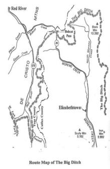
The need for organization was urgent: As many as 400 mining claims had already been staked within an eight mile radius of Baldy Peak.  This included Ute Park, where prospectors Tim Foley, Matthew Lynch, and Robert Doherty had found gold in the bed of Ute Creek, a find that would lead the following year to the discovery of the Aztec Mine, a mine that would produce over $100,000 in gold between October 1868 and July 1869.

Most of the districts placer claims were on Baldy’s western slopes, in gulches that ran from the mountain into Moreno Creek, and in the gravel in the Creek. The mines were concentrated along the lower slopes and along the Creek between Mills Gulch, three miles north of Etown, and Anniseta Gulch, 2 miles south. In addition, there were placers along the upper reaches of Willow Creek on Baldy’s southern slopes, on Ute Creek below the Aztec, and in the upper reaches of South Ponil Creek, near the outcrop of the Aztec vein.

It was only fitting that the 27-year-old New Jersey-born John Codlin should chair the effort to organize all this. He’d been part of the group (with Irishman Patrick Lyons, Prussian-born Fred Pfeffer, and a man called “Big Mich”) who’d first discovered gold at what is now Elizabethtown, a few hundred yards east of the where the town was eventually laid out, in what they named Michigan Gulch. They worked the gulch as the Michigan Company.

Codlin seems to have developed a taste for politics. He would go on to become the chairman of the Colfax County Commission in 1897-98 and to fight the 1897 transference of the county seat from Springer to Raton, a legal challenge that eventually made its way to the Supreme Court, which decided in favor of Raton. He died in April 1908 and is buried in the Springer, NM cemetery.

Source: History of New Mexico, Its Resources and People, George Anderson, Pacific States Publishing, Los Angeles, 1907; Placer Gold Deposits of New Mexico, Maureen G. Johnson, Dept. of the Interior, Geological Survey Bulletin 1348, U.S. Government Printing Office, 1972; Lure, Lore and Legends of the Moreno Valley, Moreno Valley Writers Guild, Columbine Books, 1997; Philmont, A History of New Mexico’s Cimarron Country, Lawrence R. Murphy, UNM Press, Albuquerque, 1972; Familysearch.org; 1870 United State Census Data, Colfax County, New Mexico.

The Fourth Time

She could be incandescently angry and Gerald’s trip to Santa Fe and back had taken a week longer than he’d told her it would, so he braced himself as he opened the cabin door. But Suzanna barely raised her head from the rocking chair by the fire. She wasn’t rocking. Her shawl was clutched to her chest, her face drawn and gray under the smooth, creamy-brown skin. She glanced at Gerald, then turned her face back to the flames, her cheeks tracked with tears.

Gerald’s stomach clenched. “What is it?” he asked. “The children?”

Suzanna shook her head without looking at him. “The children are fine,” she said dully. She moved a hand from the shawl and placed it on her belly. The tears started again and she looked up at him bleakly. “This is the fourth time,” she said. “There will—” She closed her eyes and shook her head. “There will be no third child,” she choked, and he crossed the room, knelt beside her, and wordlessly took her into his arms.

Copyright © 2016 Loretta Miles Tollefson