
When the Spanish settlers created the Santa Fe, New Mexico plaza in 1610, it was roughly twice the size it is today, even though they didn’t have sufficient buildings to surround it. That would come later. Certainly the newcomers had high ambitions for their new town “square.” We can see from the map created by José de Urrutia about 150 years later that it extended from the church (la parroquia) to about where the western boundary is today.

The plaza was laid out in an approximate ratio of 2 to 3, width to length, as prescribed in Spanish law. It had a number of uses—military drills, mustering livestock, small-scale trading, and general commerce, as well as social and public events. Although there’s no sign of it on the 1776 map, in the early 1600’s an acequia ran along the north side.
The acequia may have been used to water trees in the plaza. We have written documentation of at least two plantings, one prior to 1837, when Jose Francisco Perea tells us there were three cottonwoods “of the mountain variety” in what was then the northeast corner. In the mid-1840s, Governor Mariano Martinez had more cottonwoods put in, although we don’t know what type. By the time he was done, trees circled the square and additional ones had been placed along the Santa Fe river.
The square had shrunk considerably by then, to the size it is today. The 1846 map created by U.S. Corps of Engineers Lts. W.H. Emory and J.F. Gilmer reveals that the eastern half of the plaza had been filled in with buildings by that point. It had apparently been this shape for at least the last ten years. Jose Francisco Perea tells us it hadn’t changed much during that period, except for the new trees. And the fact that the square was now seldom used as a camping place and stock corral.

According to James Josiah Webb, in the 1840s the northeast corner of the plaza contained the old Mexican customs warehouse. The eastern side of the square was lined with government buildings and anchored at the southern end by a store run by Don Juan Sena.
The Pino family lived across the street, on the south side of the plaza, alongside a couple more stores, including the one rented by Leitensdorfer and Company. The crumbling adobe military chapel lay in the center of this row of buildings.
The west side of the plaza was nearly all residences, except for the old Mexican post office, and the north side was defined, as it is today, by the long low adobe structure that had been there since the beginning. The compound it fronted had served over the years as a fort, barracks for the Presidio troops, local jail, housing for the civil governor, treasury, and other functions.
Known as “el palacio” by the locals, the Americans retained the building’s basic functions after they invaded in 1846. By 1857, it included the chamber for the territorial legislature, offices for the Secretary of the Treasury and Superintendent of Indian Affairs, the post office, and (still!) the calabozo, or jail.

The building, which is still called “el palacio,” has been renovated a number of times, most recently a few years ago, and now anchors the New Mexico History Museum. It’s well worth a visit if you happen to be in town. As is the plaza. It changed once again in the 1860s, when a bandstand was added, along with walkways that crisscrossed the space. This layout has been retained ever since then. You can see it in the birds-eye view map from 1882 as well as the current map.

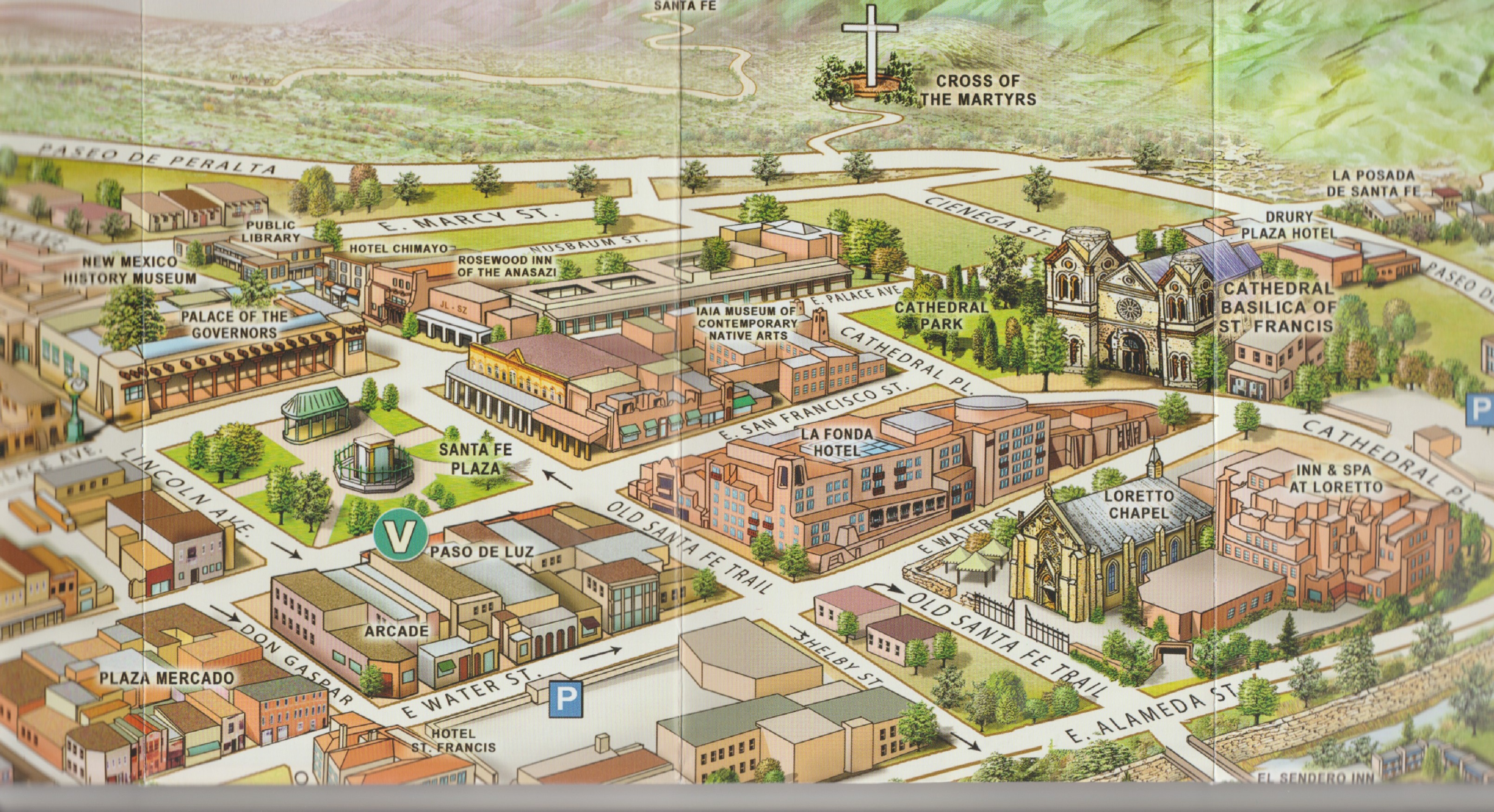
As you can see from the map, the plaza in Santa Fe is still walkable. Trees still shade the paths, and there are still small-scale traders, most often now only under the palacio house portal. It’s the perfect place to spend a few hours on Sunday afternoon or any other time.
©Loretta Miles Tollefson
