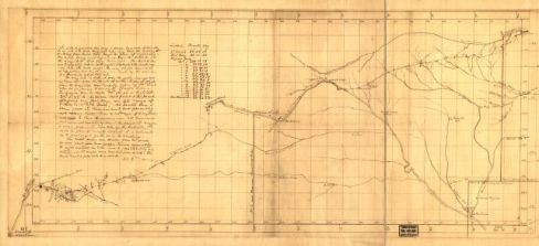
In February 1825, the United States Congress appropriated $25,000 to mark and survey a road between Missouri and Santa Fe. The survey was intended to formalize the informal trail that had been in use since at least 1821. In what would eventually become Colfax County, the “mountain branch” of the Trail crossed Raton Pass and moved directly south through what are now Cimarron and Rayado en route to Santa Fe. However, the Congressional Survey party took what was known as the Cimarron Cut Off, which swung south from the Arkansas River in what is now southwest Kansas to angle southwest until it connected with the mountain branch near Rayado.
At this point, travelers to Taos could decide whether to swing down through Santa Fe and then north or to cut west across the mountains. Taos was an important destination for those Trail travelers who were dealing in beaver fur or looking to outfit men engaged in fur trapping. Travelers headed there could take two different routes, depending on their mode of transportation. If their goods could be packed onto mules, they could follow a well-established mule track across the Cimarron range into the southern part of the Moreno Valley and then over Apache Pass to Valle Escondido. Just north of Valle Escondido, they would hit the San Fernando River, which would lead them into the Taos Valley. But if they needed to get wagons across and into Taos, they would have to find another route, such as the one Santa Fe Road Commissioner George C. Sibley followed. This route swung into the mountains south of Rayado and then north to Taos, where he completed the Santa Fe Road survey maps in late 1825.
Sources: Brown, J. C, and George Champlin Sibley. [Santa Fe route]. 1825. Map. Retrieved from the Library of Congress, <https://www.loc.gov/item/98687168/>.
Schmidt, Steve. Presentation to Santa Fe Trail Association, Cimarron, NM. June 2015.
